
RTLS Technology Comparison
You’re thinking about implementing a Real-Time Locating System (RTLS), but you don’t know which technology would best suit your needs.
Lucky for you, there are plenty to choose from… and enough options to construct the optimal solution.
Let’s dive right in.
Definition: Real-Time Locating System (RTLS)
A real-time locating system is technology, hardware and software that determine a person or item’s location. They then collect data for analysis. The use cases for this spread across a wide range of industries, from construction sites and warehouses to office buildings and hospitals. RTLS have saved organizations millions of dollars in saved time, efficiency, and reduction of “lost item” costs. They also enable industries to react quickly to unexpected challenges.
RTLS technology varies in price and function. Each have advantages and disadvantages depending on the user’s needs. While performing a site survey is the best way to determine the right technology for your use case, we have compared them below for easy research.
Types of RTLS Technology
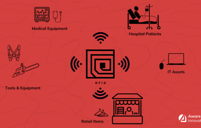
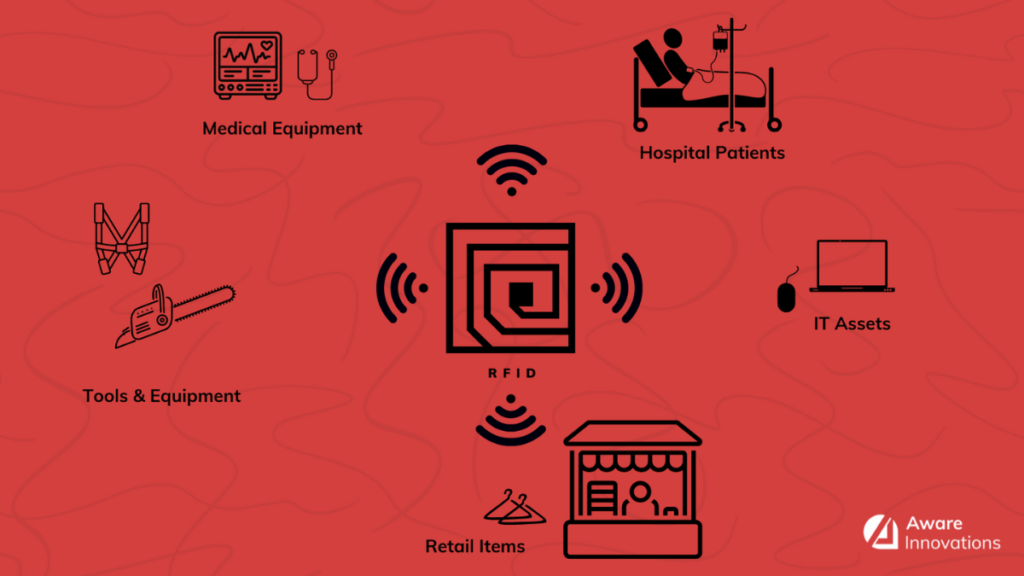
RFID (Radio Frequency Identification)
RFID is a tracking system that uses electromagnetic or radiofrequency devices to communicate with a tag (transponder). These tags are attached to items and send location data to readers (interrogators). The readers feed that information into software which reads and analyzes the data that is transmitted.
RFID is broken down into categories, measured by their frequency band: low frequency, high frequency, ultra-high frequency, and super high frequency.
This includes passive and active RFID, as well as cellular, Wi-Fi, Bluetooth (Low Energy) and Ultra-Wide Band (UWB). The following table outlines the ranges for each one.
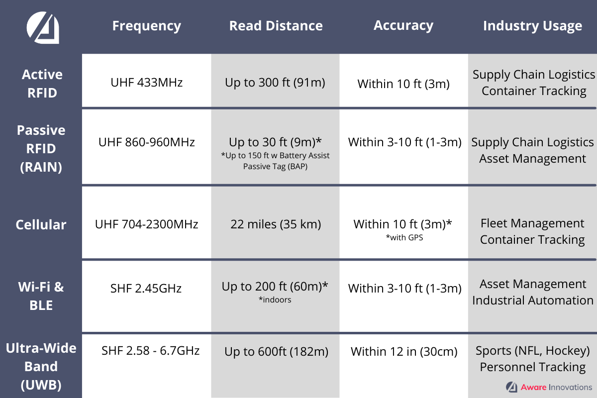
(UHF = Ultra-High Frequency, SHF = Super-High Frequency)
An important distinction between RFID systems is the method by which power is supplied to the transponder – making it either active or passive RFID.
Active RFID
Active tags have their own energy supply, such as a battery or a solar cell. This is used to provide power to the chip and generate the radio frequency signal for transmitting data to the reader.
- Use Case Examples:
- Supply chain logistics
- Container tracking
- Advantages:
- Large coverage area for each reader (up to 300ft (91 m) using technology built on commercial standard, up to 1500ft (457m) using technology built on proprietary standard)
- Long read range
- Global standards
- Less susceptible to radiofrequency interference
- Strong data signal
- Disadvantages:
- Large tags (in some cases this does not matter)
- Tag beacons still need to be in range of the reader to report
- Must consider RF physics in deployment
- Proprietary solution (if you need up to 1500ft read range) will lock you into a single supplier
- Needs replaced every 2-5 years depending on the settings
- Not printable onsite*
*RFID tags have space for a printed label that can include barcodes and human readable information.
Passive RFID (RAIN)
Passive RFID (RAIN) labels do not have a power supply. The electromagnetic field produced by the reader’s transmitter is enough to initiate response from the tag and pick up the data. However, the tag must be within the reader’s range and will only emit data when read (unlike an active tag that is always ‘on’).
- Use Case Examples:
- Supply chain logistics
- Retail
- Toll collection
- Parking systems
- Access controls
- Asset management
- Industrial automation
- Advantages:
- Lower initial cost
- Global standards
- Proven technology
- Multiple hardware and tag providers
- Hardware and tags developed for all environments
- Indefinite lifetime
- Smaller tags
- Disadvantages:
- Weaker data signal strength
- Must select proper tag based on application.
- Susceptible to RF interference must be consider in deployment
- Printable onsite
Bluetooth Low Energy (BLE)
In 1999, standards were created around ‘Bluetooth’ – a continuous point-to-point data connection for streaming data in computers, cell phones and other devices. It has become widely adopted for wireless earbuds, keyboards, speakers, etc.
Bluetooth Low Energy (BLE) was introduced in 2010 with the release of Bluetooth 4.0. This defined the protocols for communicating short bursts of data from point to point or broadcasting data to multiple devices. BLE uses less energy than previous standards and enables device configurations that can run for several years on a tiny coin-cell battery. The introduction of Bluetooth 5.0 in 2016 increased data bandwidth and range requirements while optimizing battery life. This gives developers more choice in range, speed, and broadcasting capability. BLE mesh networking specifications were released in 2017, which define networks that allow multiple devices to communicate reliably at the same time.
BLE devices operating in the broadcast mode are commonly referred to as BLE beacons. In RTLS terms, this would be the “tag”. These broadcast a message providing identity, configuration, and data from associated sensors (such as temperature, light exposure, vibration, etc.). The radiofrequency signal is used to estimate the location of the device and transfer of data.
Bluetooth beacons can be manufactured quickly and for a lower cost than competing technologies because of the simplicity of the technology.
- Use Case Examples
- Access control
- Toll collection
- Asset tracking
- Industrial automation
- Advantages
- Lower cost than traditional RTLS tags
- Long read ranges
- Wide variety of beacons (in both physical form and battery capacities)
- Some beacons can accept firmware updates or reconfiguration via networked management software (i.e., updates and configuration instructions can be installed remotely without handling every device)
- Broad vendor base
- Location accuracy can be tailored to meet business requirements (this is determined by the hardware chosen that supports various location techniques)
- Increased accuracy at any point, while maintaining the currently deployed “tag” base (by changing the receiver or sensor devices)
- Disadvantages
- Some beacons require physical interaction to update configuration or firmware (a technician must visit the physical location of the device)
- Still maturing supplier base
- Tag battery replacement cost
- Proprietary solutions will lock you into a single supplier
Wi-Fi
Wi-Fi is a wireless network that allows devices to connect to the internet. A small device known as a wireless transmitter, or hub, is required. The hub receives information from the internet via your home broadband connection. This transmitter (often referred to as a Wireless Access Point, or WAP) then converts this information into radio waves and emits it. This effectively creates a small, local, area around itself. Within this area, your devices can receive the transmitted radio signals. This area is often termed a Wireless Local Area Network, or WLAN for short.
Wi-Fi location systems use the same standards as Wi-Fi based wireless local area networks (LANs). To provide tracking of assets, a powered Wi-Fi tag utilizes the same location services used for tracking phones, computers, and other powered devices.
- Use Case Examples
- Access control
- Toll collection
- Asset tracking
- Industrial automation
- Advantages
- Wi-Fi tags allow customer to leverage existing Wi-Fi network, saving on infrastructure costs for a location system
- Long read ranges
- Multiple hardware and tag providers
- Improved location accuracy with proprietary solutions*
- Disadvantages
- Tag or battery replacement cost
- Proprietary solution will lock users into a single supplier
- Location accuracy can be diminished by radiofrequency multipath errors and daily environmental variation. (Typical asset placement errors are within 5-10 meters depending on the specific location methods utilized).
- The radio frequency band utilized by Wi-Fi is popular and prone to congestion. Adding a Wi-Fi based tracking system onto an already congested environment could result in poor performance.
*Proprietary Solution: A hardware or software product (or combination of products) and services that is tied to a specific vendor, to the exclusion of all other vendors.
Barcode
Barcodes are machine-readable codes in the form of numbers and a pattern of parallel lines of varying widths. Originally done in 1D, these tags are now done in 2D as well, enabling the capture of more complex data which can be visually represented with various geometric patterns.
Regarding location tracking, information is encoded in one or more barcodes and placed on the object. This is used to provide automated data capture of item identity and location. Information can be derived in the device and passed to the system with a hand-held imager at a workstation or choke point reading a single symbol. Other techniques rely on image capture and analysis by additional software. This allows users to capture data from multiple assets in an area such as a warehouse storage rack. Data is then passed to the application software.
- Use Case Examples
- Retail
- Shipping and receiving
- Asset management
- Mobile POS
- Advantages
- Universally adopted
- Labels can be printed on site
- Labels are attached easily
- Advanced symbology allows robust data encoding (if a portion of the symbol is damaged data can still be retrieved)
- Advanced symbology is scalable and can be printed in various sizes if an image can be acquired for analysis (very small with image access by magnification or very large with extended read distances)
- No battery replacement cost
- Disadvantages
- Requires disciplined asset handling:
- Assets must be processed, transported, and placed in storage to provide line of sight access from the reader to the label.
- If an item is moved to a new location by other than defined processes and the label is not visible, the location of that item cannot be determined
- Physical Label damage can prevent data capture (if a single line is damaged or added to a traditional barcode the encoded data cannot be retrieved)
- Limited or prohibited usage in classified areas due to image capture capability
- Wide area analysis may require illumination of the area to enable data capture
- Variations in printer quality or handwriting impact data accuracy and / or ability to read data
- Requires disciplined asset handling:
Cellular GPS
Cellular is currently used to provide communications across wide areas. Cellular companies are leveraging their existing networks to support the Internet of Things (IoT) with data plans.
Where location accuracy is required, triangulation with cell towers can be used to determine a transmitter’s location (similar to GPS tracking). But when greater location accuracy is required, embedded GPS can be combined with cellular backhaul capabilities. The cellular GPS system has the capacity to serve tens of thousands of subscribers in a major metropolitan area and is highly successful for outdoor environments that need tracking solutions.
- Use Case Examples
- Fleet management
- Container tracking
- Asset management
- Advantages
- Leverages existing cellular network; does not require dedicated infrastructure installed and maintained to collect data from tags.
- Ability to connect to a power source or be battery powered
- Rapidly deployable
- Easy installation and deployment
- Over-the-air programable
- Over-the-air serviceability status updates
- Accelerometer available for motion sensing
- Ability to pass live sensor data
- Ability to pass telematics
- Disadvantages
- Requires a data plan
- Battery replacement
- Battery can be rapidly depleted depending on programing and device settings
- Location accuracy inside building
- Some providers require you to use their service
Ultra-Wideband (UWB)
Ultra-Wideband (UWB) is a type of RFID technology that uses an extremely low power level and super high transmitting frequency to provide tag information for location-based solutions. A UWB real-time locating system can track thousands of tags precisely, in a large area like a warehouse, or a single tag in a small coverage zone like a doorway.
UWB systems communicate over long distances with less degradation in performance. The reader can focus on a specific area to interrogate the tags, so UWB systems provide greater location accuracy than other systems.
- Use Case Examples
- Sports (NFL, Hockey)
- Manufacturing work in progress
- Personnel tracking/safety
- Advantages
- UWB transmits at such a low power level and across such a wide frequency range that it does not affect other wireless technologies such as Wi-Fi, Bluetooth, UHF, or handheld passive readers
- High performance around metallic surfaces
- Resistant to signal jamming and tampering
- Good penetration properties
- Omni directional antennas
- Long read ranges
- Location accuracy
- No spectrum licensing required
- No limitation to worldwide operations
- Disadvantages
- Proprietary solution
- No standard
- Tag or battery replacement cost
Conclusion – RTLS Saves Companies Millions
RTLS and the associated technology are critical for providing accurate sensing, locating, and tracking data that guide business decisions and increase agility. Companies that have deployed RTLS systems have saved millions in efficiency, reduction of item loss and increased productivity. They are more nimble and able to react to market changes and shifting demands. As RTLS continues to be more widely adopted and technology innovation increases, the implementation becomes easier and more uniquely fitted to your business needs.
About the Authors
Bart Ivy, PMP, is our Director of Automated Identification Data Collection (AIDC) and Radio Frequency Identification (RFID) Solutions. A retired Air Force Chief Master Sergeant and certified Project Management Professional, he handles your solution design. From defining technical requirements to deploying and sustaining your system, he ensures high-quality services that satisfy your needs. Bart is an expert in the industry and works with these technologies every single day. He’s our go-to guy for information on deploying real-time locating systems.
Elyse Cheatwood is our Marketing Manager. With ten years in marketing and ever-increasing knowledge of the Automated Identification Data Collection (AIDC) industry, she creates research-driven content based on market trends, industry updates and tech insights from reputable sources (including the professionals she works alongside).
