Categories
Cellular GPS RTLS Software

Cellular GPS – DLA Gains 87% in Labor Savings

Red River Army Depot uses Cellular GPS for a pilot to track over 23,000 military vehicles

Summary

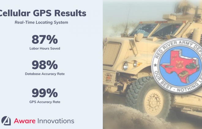
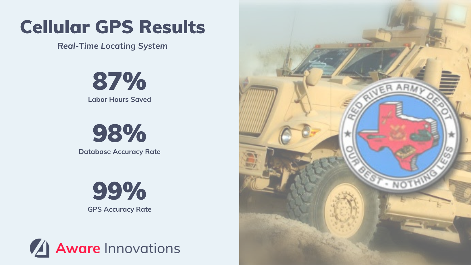
The Defense Logistics Agency’s Red River Army Depot reduced wasted personnel hours by 87%, using cellular GPS to track 23,000 military vehicles. During this pilot, the DLA was able to reduce the time it took to find a vehicle from upwards of 8 hours per vehicle to 30 minutes or less using Cellular GPS.

Evanhoe & Associates, Aware Innovations’ parent company at the time, was contracted to implement a real-time locating system for DLA as a pilot for 3 years. Bart Ivy, our Director of Automatic Identification and Data Capture (AIDC) Solutions, conducted a site survey, market research and a concept of operations (CONOPS) for DLA, recommending Cellular GPS as the best technology solution for their use case. DLA accepted the proposal, allowed Evanhoe (Aware) to execute the solution and saw the following results:

  • A real-time locating system (RTLS), operational 24/7/365 in all weather conditions
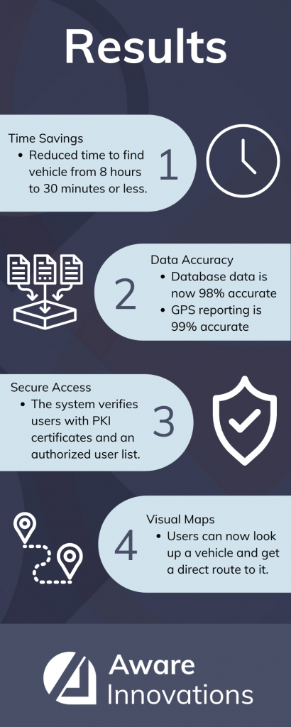
  • Time savings of over 87%: time to locate a vehicle was reduced from upwards of 8 hours to less than an hour
    • Man-hours were repurposed to profit-driving tasks
  • 98% accuracy rate of database data, with data current to within 14 hours
  • 98.69% GPS accuracy rate over 27 months
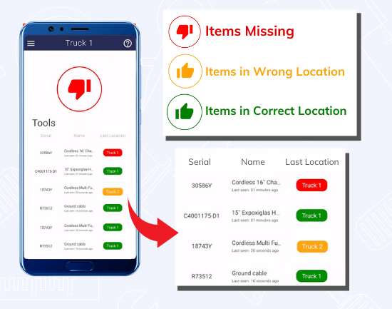
  • Instant location data with a map feature in ItemAware that gives users a visual route to the vehicle
  • An interface of location-specific vehicle data (serial numbers, item unique identification (IUID), etc.) with DLA’s Distribution Standard System (DSS)
    • This consolidates data from a wide variety of uncommon assets (from multiple locations) into a central, accessible database
  • System verification to authorize users by comparing their PKI certificates against an authorized user list
    • User roles and permissions were used to control the level of access to the system date once authenticated

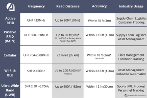
Overview: RTLS Pilot Using Cellular GPS

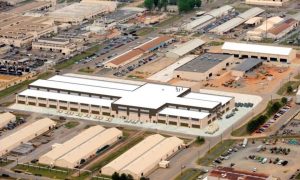
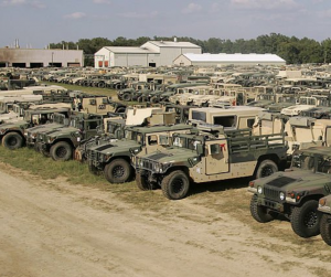
The Defense Logistics Agency (DLA) sought to establish a materiel asset identification and location tracking system for 23,000 vehicles on its 15,375-acre lot in Red River Texas. With vehicles stored on 24 different sites on over 9 million square feet of storage, locating them was a tremendous task, and one that involved manual data uploads. This project resulted in site surveys and multiple reports on solutions, as well as an execution of the system for 3 years.

DLA wanted a system that:

  • Leveraged Item Unique Identification (IUID) or Serial Numbers (SN) written to various Automatic Identification Technology (AIT) tools and devices
  • Enabled continuous asset visibility, accountability, chain of custody and on-time/on-command reporting
  • Consolidated the data from a wide variety of uncommon assets in multiple locations into a common database accurate to above 98% with data current to within 14 hours
  • Had security for loss prevention or unauthorized removal from/relocation within storage facilities (for sensitive, classified or pilferable assets)

CSRA International had an existing pRFID III contract with DLA and was awarded a task order under that contract to implement what ended up being a pilot. CSRA used Evanhoe & Associates, Aware Innovations’ parent company at the time, as their technical Engineering partner. Bart Ivy led a team to execute this solution once Cellular GPS was chosen.

If you want to learn more about Red River’s mission with these vehicles, watch here.

Background: What Is the Defense Logistics Agency?

The Defense Logistics Agency (DLA) was started in 1961 to manage supplies for the US military. Today, it continues to support the US warfighter with locations in nearly every state and in over 28 countries worldwide.

The DLA provides more than $41.8 billion in goods and services every year, supporting more than 2,400 weapons systems and employing 26,000 civilians and military. It manages nine supply chains and nearly 5 million items. The focus of this use case is on their Red River Army Depot (RRAD).

Opportunity: A Manual Tracking Process That Proved Inefficient – And Dangerous

The Army Depot’s System of Record

The Distribution Standard System (DSS) is the Army Depot’s system of record. Not included in the DSS’ core functionality, however, is specific data necessary for uniquely identifying and tracking vehicles. The Vehicle Tracking System (VTRC) was developed to remedy this, providing fields for serial number, NSN, condition code, ownership code and location. However, there is no interface between the VTRC and DSS, so personnel must manually enter all data long after the work is accomplished. This makes it prone to error in keystrokes, the same data being entered differently, and induced data latency and inaccuracy if manual paperwork had discrepancies.

Manpower-Intensive Effort

The massive quantity of vehicles stored over such a large distance posed a challenge to RRAD. Finding and identifying each vehicle took hours. Historical records show that if any errors were made in the manual record keeping process, the identification process was prolonged – even up to 8 hours. Additionally, these vehicles are involved in nearly 15,000 official moves (issues and receipts when the Depot receives and deploys vehicles FY to date; or 1,994 per month), which adds more complexity.

“Imagine going to a mall in a white Prius,” Bart Ivy, Evanhoe’s (Aware Innovation’s) director of the AIDC project at RRAD states, “you come outside after shopping and there are 500 white Priuses parked next to you. This makes your Prius nearly impossible to find. The vehicles at RRAD are this scenario times ten. All of them the same, across miles of land. And the RRAD team is tasked with finding an exact one.”

Harsh Conditions and Dangerous Wildlife

In addition to the quantity of vehicles and the scale of the property, the terrain and outdoor elements in this location posed their own threats.

Many of the tags became eroded over time due to inclement weather. Employees who were trying to identify these vehicles had to wade into knee-deep mud in some areas, with brush up to their chests. Wildlife is also an issue in Northeastern Texas and interacting with rattlesnakes is not uncommon. The identification process also required employees to climb up onto the vehicle, posing physical challenges to some.

Solution: Cellular GPS Saves the Day, Requiring Zero Infrastructure

Requirements

Given the many challenges that faced DLA’s tracking process, the Defense Logistics Agency published requirements for a real-time locating system that included:

  • Operational 24/7/365 in all weather conditions
  • Reporting accuracy of approximately 10 feet
  • Locations provided in both narrative and visual mode
  • Ability to differentiate between multiple assets located immediately adjacent to and surrounded by like assets
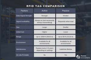
  • A reusable tag that:
    • is easy to attach and remove, but difficult to become disassociated on its own
    • can report its status (last known location, last reported, battery life, etc.)
    • has a long service life and flags system if it becomes unresponsive or fails
  • Ability to interface with DSS, providing and receiving information
  • Event programmable
  • Report on movements, processing, workload, and productivity
  • Long span between any maintenance or update requirements
  • Expandable to other assets upon procurement of additional tags
  • Able to provide diagnostics in self-reporting mode
  • Have a user interface for authorized employees to the system, to allow user query and other work, auditing, and productivity management functions.

The DLA also required that the technology used be based on international standards to allow for competitive bidding of equipment as well as technologies that are readily available on the commercial market.
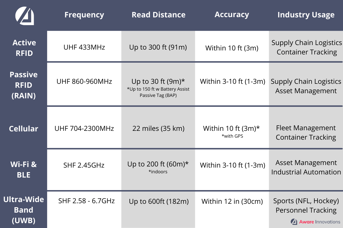
Cellular GPS

In a comprehensive market research report comparing real-time locating technology options, Bart Ivy recommended using Cellular GPS as the best option to support the DLA’s requirements.

Cellular GPS would be quick to deploy, with no infrastructure – eliminating costly requirements like moving vehicles for installation or long-term maintenance costs for structures that are in harsh conditions. GPS would also provide agility in parking requirements and vehicle movement that infrastructure would otherwise restrict.

Cellular GPS is over-the-air programmable, and motion sensor data and telematics can be transmitted to the software application that would interface with DSS. Each tag has an estimated 5–7-year battery life, making it the best long-term solution. It would improve location accuracy and provide instant updates when equipment is moved without user intervention.

The tags can also be associated with various items, allowing the DLA to reuse them, and provide a visual overlay on the ItemAware software app so that personnel can drive right to the vehicle with the provided route from their current location.

Execution: The Road to Automation

Decision-Making and Installation of GPS

Bart Ivy and 20 team members then deployed to tag all vehicles, associate the tags to the vehicles, and connect them to the database over the course of four months.

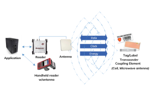
They connected the GPS to an RTLS module that allows multiple technologies from multiple locations to transmit data to the DSS and its subsystems. This technology included four main components: Edge Collection, Event Processor, API/Web and datastore. These four components integrated to create a complete system for managing, tracking, and inventorying containers and components therein. The ItemAware Asset Tracking and Inventory Management Software was selected to interface with DSS and display data to users. ItemAware has intuitive map features; item data, location, and status tracking; and much more.

“The genius of this system is integrating all data from all sites with multiple technologies into the DSS, allowing users to pull multiple data sets from one system.” Bart Ivy stated, discussing the efficiency it created by connecting not only the information at Red River, but multiple sites across the U.S., allowing verified users to access the information they need, instantly.

Evanhoe (Aware) developed custom interfaces with the DLA and Army Enterprise system and developed customer applications to support DLA’s work processes, enabling them to utilize this new technology and leverage its capabilities.

Challenges

Tags

Tags that the DLA had already purchased were opted for over the recommended tags, in order to save money. To make these work for the use case, the team had to address a couple issues:

First, the team discovered that the GPS location being reported by the tags was not their actual location.  After back-and-forth with the manufacturer, the manufacturer discovered they had made an error in their hardware configuration management resulting in several hundred tags’ SIM chip being associated to the wrong tag serial number.  Once resolved, the location of the GPS tags was accurate.

Secondly, the solar battery did not work well with the location of the equipment. As expected, solar power tags require sufficient sunlight to power the system; however, not all equipment was parked in locations where they received enough power to recharge the battery. When the tags were removed from equipment and stored until required again, they would not charge sufficiently to power the tag’s hardware. To resolve this issue, the removed tags were attached to the outside of the building to allow the tags to retain their solar charge. When the tag worked, the location accuracy was excellent.

Data Inaccuracies

Numerous data error problems that stemmed from manual entries had to be cleaned up and resolved during the data interface process. The team spent hours writing a script to clean the data prior to importing the data into the RTLS system, increasing the accuracy rate to 98%.

Results

The Evanhoe (Aware) team was able to meet the DLA’s requirements for an efficient system that tracked 23,000 vehicles in real-time, giving users instant location updates and directions to every vehicle tracked. It met data accuracy requirements and allowed verified users across the DLA to access information. The DLA continued to run this pilot over the course of 3 years. The management changed at that time and took the program a different direction, but we saw the following results in the meantime:

Time Savings

Our solution cut wasted time by over 87% – reducing the time it took to find a vehicle from 8 hours to 30 minutes or less. The vehicle’s location was able to be pulled up immediately, a pin shown on a map, and a route mapped out to get the user to the vehicle in the most efficient way possible. The amount of time it takes to reach a vehicle depends on the user’s current location but with our solution, it could be done in under an hour. This allowed DLA to repurpose 7-man hours per vehicle to focus on other work.

Data Accuracy

Scrubbing and entering correct data into the system made the database meet the requirements of a 98% accuracy rate.

Last reported GPS reporting accuracy was 99.8% at one location and 99.0% at the other, with a 98.69% over 27 months.

Access

The system was designed to verify authorized users by comparing their PKI certificates against an authorized user list.  User roles and permissions were used to control the level of access to the system data once authenticated.

ConclusionCellular GPS is Successful

Our team was able to design and execute a successful real-time locating system that met the requirements of the government and all stated goals of the project provided by the government.

About the Author

Elyse Cheatwood is our Marketing Manager. With ten years in marketing and ever-increasing knowledge of the Automated Identification Data Collection (AIDC) industry, she creates research-driven content based on market trends, industry updates and tech insights from reputable sources (including the professionals she works alongside).

Categories
RFID RTLS

RFID – What You Need To Know

RFID, or Radio Frequency Identification, is a technology we’re sure you’ve heard of by now. After all, it’s ability to track item location and data provide endless benefits:

  • Increased supply chain efficiency
  • Reduced human errors in inventory
  • Eliminated cost of replacing lost or stolen items
  • Elevated security
  • And more….

It has numerous applications:

Companies and organizations have increasingly adopted this technology for the above benefits, and have additionally realized the advantage it provides in reacting to unforeseen events such as COVID-19. Subsequently, using RFID or another tracking technology is essential to remaining competitive in today’s market.

But where do you start?

We’ve been in the industry a long time and provide a basic overview of RFID below so that you can begin your journey towards efficiency, lower operation costs, security and more. To see how RFID compares to other tracking technologies, see this article.

Radio Frequency Types

RFID functions on radio wave frequencies, which are measured within frequency bands: low frequency, high frequency, ultra-high frequency (such as RAIN RFID) and super-high frequency.  These terms refer to the wavelengths of the frequency – low frequency has longer wavelengths, which increase and shorten as the frequency gets higher.

Frequencies determine the strength and distance of the signal. Low frequency usually has a weaker signal and a shorter read distance but is less affected by disruptors to radio frequencies (such as liquid or metals). This is important for environments that may require RFID tags to interact with these substances. Higher frequencies promise a stronger signal and one that reads at a farther distance but is more sensitive to disruption from various materials1.

This table compares frequency bands and the technology used in each one:

Chart comparing different real-time locating system technology.

Predominant RFID

Within the world of RFID material handling there are two predominate technologies used; HF and UHF.  UHF is the most predominate of the two due to its long-read ranges.  HF is used when short read ranges are desirable (such as use cases requiring isolation) or when the laws of physics prohibit the use of UHF (such as tracking of items that contain large quantities of water).

For this article, we will focus on the UHF frequency band.

RFID System Components

RFID systems are always comprised of two primary components: a transponder (tag/label) that goes on the item being tracked and the interrogator (reader). These components work together to store data about an item’s location, transmit that data and ultimately distill that data into usable information via a software application. Software apps, such as ItemAware, allow users to look up an item, see its location, and add additional data about the item (such as maintenance information, item history and much more).


Components of RFID System

RFID Tags: Passive, Semi-Active, Active

RFID tags are placed on every item that is going to be tracked. Different types and sizes of RFID tags determine versatility for different environments, infrastructures, and cost thresholds. A main distinction between tags is the method by which power is supplied to them – determining if they are passive or active.

First, let’s break down the types of RFID tags and how they work:

Passive RFID Tags are the simplest RFID tag, only containing an integrated circuit and an antenna. They do not transmit signals to readers, but rather engage when a reader sends a signal to the antenna. This is done through backscatter technology – without signals from the reader, the tag remains inactive. If the tag is located outside the reader’s range, the tag won’t have sufficient energy to send information to the reader. Because the tag does not contain a battery, they last indefinitely.

Semi-Active RFID Tags (also called semi-passive or battery-assisted passive (BAP) tags) communicate the same way that passive tags do – by receiving a signal from the reader. However, the semi-active tag circuitry is powered by a battery. The battery enables a longer read range than passive tags, but not as long as an active tag.

Active RFID Tags have their own energy supply, e.g. a battery or a solar cell, which is used to provide power to the chip and generate the RF signal for transmitting data to the reader.  Given that the strong electromagnetic field needed to power a passive tag is not necessary, the distance from the tag to reader can be significantly increased, yielding an increased coverage area for each reader. The battery typically lasts around 2-5 years before being replaced. Active tags can offer a longer read range – up to 1000ft / 304m – and are often used on items that need to be tracked over long distances.

Tags can be used on multiple items throughout their existence.

Tag Cost

The price of RFID tags considers the durability, frequency, volume of tags needed, etc. This means that there is not a straightforward price to share for each tag; however, passive tags are less costly than semi-active and active tags, and prices generally fall in these ranges (NOTE: prices do change based on the market, inflation, demand, etc.):

  • Active: Active RFID tags start around $25 / tag upwards of $100 tag.
  • Semi-Active: usually cost around $10-$25 per tag.
  • Passive: Passive RFID tags cost anywhere from $0.07 to $0.50 each

It is often assumed that passive RFID is the cheapest option on the market – and, when looking at tag price alone, this is true – but there are many factors that go into a final cost. Which means that what makes up your cheapest option depends on your requirements and the factors we continue to explore in the rest of this article.

Tag Sizes and Types

RFID tags come in a wide range of sizes. Active tags are generally larger because they have more components, while passive RFID tags can be as small as a grain of rice.2 Our engineers are continually engineering solutions that allow tags to affix to items properly so that they do not obstruct function and avoid being destroyed when an item is used. A recent example includes inserting a tag into a divot on a chainsaw for tool tracking, so that the chainsaw is tracked without risking damage to the tag during use. Another example is tamper-evident tags that are placed on weapons boxes. If the box is tampered with, the tag alerts users (like a security officer), increasing security and minimizing theft.

Since use cases are broad and tag options are numerous, it is best to talk to a professional to determine which tag is right for your situation.

Chart comparing RFID Tags

RFID Readers

Readers are essential for the RFID system as they send signals to tags and collect tag data. They fall into two main categories: fixed and mobile.

Fixed readers allow users to track items as they pass through chokepoints (such as entryways, stairwells, etc.). When an item passes through a chokepoint, the data is collected by the reader and communicates to the user that the item has moved from one location to the next. Fixed readers are the most expensive category of readers, but they also have the highest read range. A subset of fixed readers is an integrated reader which is often used in visible areas of indoor locations, because of its sleeker design.3

Mobile readers come in a variety of forms from a Mobile Computing Device that has an onboard computer, to a Sled that can fit on a person’s mobile phone and transfer data through Bluetooth or auxiliary connection. Users walk through inventory and scan to read the tags in that location with handheld readers. These readers are usually more cost-effective than fixed readers and are especially effective when searching for a specific item in an exact location.3 Once again, the right reader is determined by use case.

Examples:


An Integrated Fixed Reader: the Impinj Speedway xPortal R640 Reader used at the US Patent and Trademark Office


Zebra MC3300 RFID Series Mobile Computer

RFID Antennas

Antennas are another essential component of an RFID system, as they create the communication between the reader and the tag. Antennas are placed on both the reader (to send the signal to the tags) and on the tags that receive the signal (in turn transmitting the information that the chip is storing).

The signal strength between a tag and reader can be determined by the antennas, their size, polarity, and the degree of wave expansion as it leaves the antenna.4

Times-7 A5020 RAIN RFID Antennas offer the high performance and range needed for high traffic tracking with precision. 


SummaryThere are numerous reasons that go into choosing a technology that’s right for your needs: how a technology interacts with its environment, the current infrastructure, costs associated, if you need constant monitoring of an item, the value of the items you’re tracking and much more. While research can give you an idea of what might be best for you, it’s important to speak with a professional to make sure you are getting the best possible solution, with the highest return on investment. That’s why we are a full-service asset tracking and inventory management company. We built our own software (to create the best features on the market) and we specialize in the integration of hardware and software so that you can go from “start” to “tracking” with one company. We also source all hardware for you with our hardware partners that we’ve vetted to be the best. Contact us today!


Additional Sources

  1. https://www.impinj.com/products/technology/how-can-rfid-systems-be-categorized
  2. https://www.rfidjournal.com/question/what-is-the-smallest-passive-rfid-tag
  3. 1 (awareinnovations.com)
  4. https://www.analogictips.com/rfid-tag-and-reader-antennas/

Authors

 Bart Ivy, PMP

Bart is our Director of Automated Identification Data Collection (AIDC) and Radio Frequency Identification (RFID) Solutions. A retired Air Force Chief Master Sergeant and certified Project Management Professional, he handles your solution design. From defining technical requirements to deploying and sustaining your system, he ensures high-quality services that satisfy your needs. Bart is an expert in the industry and works with these technologies every single day. He’s our go-to guy for information on deploying real-time locating systems.

 Elyse Cheatwood

Elyse is our Marketing Manager. With ten years in marketing and ever-increasing knowledge of the Automated Identification Data Collection (AIDC) industry, she creates research-driven content based on market trends, industry updates and tech insights from reputable sources (including the professionals she works alongside).


Categories
Quality RTLS Software Traceability

Meet Kindra: Our Software Test Lead

Kindra Davis holds the position of Software Test Lead. By definition, the basic responsibility of any Software Test Lead is to “effectively lead a team of testers to meet the product goals and thereby achieving the organizational goals that are derived.” Kindra does this and more. Her job is to test all of our software to ensure quality and ease of use. When our team reacts to customer requirements, she is at the helm to ensure needs are met – and met with excellence.

We filmed this short video to give viewers an idea of what our Software Test Team does and how they do it. In it, Kindra talks about how she ensures the quality and consistency of our software.

Video Text

“Hi, my name is Kindra Davis and I have been with Aware Innovations since the beginning, so approximately four-and-a-half years now. My job is to ensure the quality and consistency of the software products that we’re producing. I do that by determining how I’m going to test/test plan, running through various test scenarios, and working with the developers to give them feedback on what went right, what went wrong, and what we can do better.

Aware Innovations is a company that assists customers in tracking, locating and sensing assets. So basically, to give the customer a full visibility of what they have and where it is at any given point in time. We have several industry leaders on our team with years of experience in this industry that assist customers with consulting, system design, hardware and software installation, and training and support.

ItemAware helps ensure critical medical equipment is where it should be at all times.

One example, one installation, would be a healthcare installation – such as hospital equipment itself. There’s sensitive equipment in a hospital that needs to be in certain places at all times. This would allow the hospital to inventory their equipment, know where it is, and to ensure that the right tools are in the right place at the right time.

I love the people that I work with. I get along with everybody really well. [Everyone’s] personalities are interesting, and we work together well, which leads into teamwork. It’s a relaxed but productive environment, and the technology is just neat that we’re working with.”

About the Author

Elyse Cheatwood is our Marketing Manager. With ten years in marketing and ever-increasing knowledge of the Automated Identification Data Collection (AIDC) industry, she creates research-driven content based on market trends, industry updates and tech insights from reputable sources (including the professionals she works alongside).

Categories
Events

Utility Expo 2021 – Join Us!

We are headed to the Utility Expo in Louisville Kentucky from September 28 – September 30, 2021! Join us and stop by our booth #N1151, to see a live demo of our ItemAware Tool Tracking Solution.

Special Offer – Use Our Code & SAVE!

We cordially invite you to attend The Utility Expo 2021 and visit us at booth N1151. Register early to save time and save money. When you register now with our promo code AWA110C, you will save 43% on each show badge, valid through September 27!

Register Now and Save

What is The Utility Expo and Why Should You Attend?

The Utility Expo is the utility industry’s largest trade show held every two years. Covering 30+ acres of indoor and outdoor exhibits, the show brings together more than 19,000 construction and utility professionals.  Here are your top 5 reasons to attend:

More Hands-On Demos

Get your hands on over 30 acres of new equipment, advanced technology, and safety products to see, try and add to your fleet.

The Jobsite Presented by Planet Underground

A peer-to-peer area where contractors learn from other contractors and service providers with a focus on safety and damage prevention. The Jobsite will feature live utilities, providing a realistic working environment.

Learn from the Best

Field classrooms right on the show floor covering the industry’s hottest topics including fleet management, utility locating, pipeline maintenance and more.

Meet the Experts

Leading experts and innovators in manufacturing and technology share their knowledge and experience to show you how to get the most from your equipment.

Expand Your Network at the Utility Expo

Face-to-face opportunities to build lasting connections with your utility professional peers.

The Utility Expo only happens once every two years. Don’t miss your chance to get informed & see the latest industry developments September 28-30, 2021.

Remember to use our code AWA110C to save 43% on registration fees! Register by September 27 for the best rate.

Register Now and Save

Health & Safety Commitment Message from The Utility Expo:

We’re looking forward to bringing our industry back together in Louisville. Your health and safety are our top priority. We are following the guidelines of the CDC and we are working closely with the Kentucky Exposition Center to ensure a safe and rewarding experience for all. Please check our website for the latest information.

To request more information about our software solutions, click here.

Categories
Inventory Management ItemAware RFID Software

Utility Industry Uses ItemAware for Tool Tracking

The utility industry estimates a 30% annual loss rate of tools, i.e., upwards of $900,000,000 “lost” items annually. 

Aware Innovations is excited to introduce ItemAware software to the utility industry to help eliminate the cost of lost items.

What is ItemAware?

ItemAware tracks tools, equipment and more, giving users full visibility of assets as well as all designated locations (trucks, sheds, jobsites, etc.). This allows users to know when an item is missing or has been put in the wrong location.

Tracking systems allow companies to stay nimble, react quickly and devote time and money toward actual business goals. Our software is a mobile, intuitive software that easily integrates with multiple technologies.

It can be used on your enterprise system, or we can host it for you. Designed to be flexible, ItemAware is customizable to your situation, your environment, your goals.

How it Works

  • Tag Items with right-size, durable RFID tags
  • Designate locations and assign tools to each location (truck, shed, jobsite, etc.)
  • Use the ItemAware app to see each item’s status and last-seen location
  • Click on items to see item-level details (such as history, manufacturer, and more)

Intuitive & Mobile Color-Coded Icons

ItemAware uses color-coded icons so that users can quickly glance at their mobile device and know if they have all items (green thumbs up), if an item is in the wrong location (orange thumbs up) or if any items are missing (red thumbs down).

First-Hand Experience in the Utility Industry

Concurrent Group, a customer of RingPower Utility Equipment, uses our tool tracking software and gives feedback on this cutting-edge solution on our ItemAware website. To learn more about ItemAware’s application in the Utility Industry or to request a free 30-minute demo, click here.

About the Author

Elyse Cheatwood is our Marketing Manager. With ten years in marketing and ever-increasing knowledge of the Automated Identification Data Collection (AIDC) industry, she creates research-driven content based on market trends, industry updates and tech insights from reputable sources (including the professionals she works alongside).

Categories
Compliance ItemAware RFID

Sarbanes-Oxley Compliance and RFID

RFID can help businesses pass audits and fulfill requirements imposed by the Sarbanes-Oxley act (SOX) – a law that has had drastic operational and financial impacts on U.S. companies.  

Background

Nearly twenty years ago, in 2002, the Sarbanes-Oxley Act was created to hold publicly traded companies accountable for their financial reporting.

This came after some of the U.S.’s largest companies were exposed for financial scandal. Unethical business practices and falsified financial statements landed these companies in bankruptcy – evaporating employee’s retirement plans and crumbling investor trust in corporations.1

What is Sarbanes-Oxley?

SOX implemented rigorous controls for financial reporting and auditing. This was done to ensure the accuracy of corporate disclosures, with a hefty criminal charge for non-compliance.

With the creation of SOX, companies quickly made investments in controls that would help them pass audits. However, many continue to underestimate the massive undertaking of accounting for assets and rely on a large workforce and static spreadsheets for reporting.

RFID can revolutionize this process – eliminating human error, showing asset status in real-time and being a reliable source for data.

RFID’s Role in Sarbanes-Oxley Compliance

RFID is an efficient, accessible technology that collects data from items (think medical supplies, tools, IT assets and anything in between) and provides real-time reports with item status, history, and location.

RFID can play a critical role in SOX compliance by:

  • Increasing Reporting Accuracy:
    • SOX Requirement: A company’s financial statements must be accurate to the best of the executive officer’s and chief financial officer’s knowledge.2
    • RFID Benefit: Assets play a role on a company’s financial statement – and an inaccurate count can lead to errors in reporting. Manual asset tracking is prone to human error and risks this accuracy. Automating this process with RFID diminishes that possibility as readers collect, organize, and report the data. This ensures that everything is accounted for – which can reduce loss rates by as much as 99%.
  • Disclosing in Real-Time:
    • SOX Requirement: Section 409 of the Sarbanes-Oxley act requires that material changes in a company’s financial condition or operations are required to disclose the information on an almost real-time basis (within 48 hours).3
    • RFID Benefit: Automatic data can capture supplies’ real-time information as readers read the RFID tags. This can be done with continual updates or by passive readers that scan an item any time it passes by (such as entering a new location). Software receives this information and organizes it, then feeds it to the user. Users can even get automated alerts when an item’s information changes.
  • Providing Traceable Source Data:
    • SOX Requirement: any source data in financial reports must be traceable and any changes documented.4
    • RFID: Data pulled from RFID readers is easily viewed. All changes to any assets are recorded and kept with the pertaining asset. This allows users to trace all information and keep it updated as changes occur.

Other Benefits of RFID

RFID’s features directly correlate to the SOX requirements mentioned above – but it has other ways it supports this as well:

  • Simple Reporting: RFID makes running reports incredibly easy as data is continuously updated and ready to be pulled at any time. Users can enter the parameters and get up-to-date information within minutes, rather than waiting for a manual count or referencing a previous report.
  • ERP Integration: ERP systems are often employed to help with SOX compliance. RFID software, such as ItemAware, can easily integrate with these systems making it easier to share and pull information.

Conclusion

Ensuring that your company is meeting all requirements to Sarbanes-Oxley is crucial, and RFID can make that process easier.

Index

  1. https://www.investopedia.com/terms/s/sarbanesoxleyact.asp
  2. https://isgovern.com/blog/sox-compliance-act-and-public-funding-financial-reporting/
  3. https://www.sec.gov/news/press/2003-6.htm
  4. https://learnidentityandaccessmanagement.com/sox-compliance/

About the Author

Elyse Cheatwood is our Marketing Manager. With ten years in marketing and ever-increasing knowledge of the Automated Identification Data Collection (AIDC) industry, she creates research-driven content based on market trends, industry updates and tech insights from reputable sources (including the professionals she works alongside).

Categories
RFID RTLS Uncategorized

RTLS Technology Comparison

You’re thinking about implementing a Real-Time Locating System (RTLS), but you don’t know which technology would best suit your needs.

Lucky for you, there are plenty to choose from… and enough options to construct the optimal solution.

Let’s dive right in.

Definition: Real-Time Locating System (RTLS)

A real-time locating system is technology, hardware and software that determine a person or item’s location. They then collect data for analysis. The use cases for this spread across a wide range of industries, from construction sites and warehouses to office buildings and hospitals. RTLS have saved organizations millions of dollars in saved time, efficiency, and reduction of “lost item” costs. They also enable industries to react quickly to unexpected challenges.

RTLS technology varies in price and function. Each have advantages and disadvantages depending on the user’s needs. While performing a site survey is the best way to determine the right technology for your use case, we have compared them below for easy research.

Types of RTLS Technology

RFID (Radio Frequency Identification)

RFID is a tracking system that uses electromagnetic or radiofrequency devices to communicate with a tag (transponder). These tags are attached to items and send location data to readers (interrogators). The readers feed that information into software which reads and analyzes the data that is transmitted.

RFID is broken down into categories, measured by their frequency band: low frequency, high frequency, ultra-high frequency, and super high frequency.

This includes passive and active RFID, as well as cellular, Wi-Fi, Bluetooth (Low Energy) and Ultra-Wide Band (UWB). The following table outlines the ranges for each one.

Chart comparing different real-time locating system technology.

(UHF = Ultra-High Frequency, SHF = Super-High Frequency)

An important distinction between RFID systems is the method by which power is supplied to the transponder – making it either active or passive RFID.

Active RFID

Active tags have their own energy supply, such as a battery or a solar cell. This is used to provide power to the chip and generate the radio frequency signal for transmitting data to the reader.

  • Use Case Examples:
    • Supply chain logistics
    • Container tracking
  • Advantages:
    • Large coverage area for each reader (up to 300ft (91 m) using technology built on commercial standard, up to 1500ft (457m) using technology built on proprietary standard)
    • Long read range
    • Global standards
    • Less susceptible to radiofrequency interference
    • Strong data signal
  • Disadvantages:
    • Large tags (in some cases this does not matter)
    • Tag beacons still need to be in range of the reader to report
    • Must consider RF physics in deployment
    • Proprietary solution (if you need up to 1500ft read range) will lock you into a single supplier 
    • Needs replaced every 2-5 years depending on the settings
    • Not printable onsite*

*RFID tags have space for a printed label that can include barcodes and human readable information.

Passive RFID (RAIN)

Passive RFID (RAIN) labels do not have a power supply. The electromagnetic field produced by the reader’s transmitter is enough to initiate response from the tag and pick up the data. However, the tag must be within the reader’s range and will only emit data when read (unlike an active tag that is always ‘on’).

  • Use Case Examples:
    • Supply chain logistics
    • Retail
    • Toll collection
    • Parking systems
    • Access controls
    • Asset management
    • Industrial automation
  • Advantages:
    • Lower initial cost
    • Global standards
    • Proven technology
    • Multiple hardware and tag providers
    • Hardware and tags developed for all environments
    • Indefinite lifetime
    • Smaller tags
  • Disadvantages:
    • Weaker data signal strength
    • Must select proper tag based on application.
    • Susceptible to RF interference must be consider in deployment
    • Printable onsite

Bluetooth Low Energy (BLE)

In 1999, standards were created around ‘Bluetooth’ – a continuous point-to-point data connection for streaming data in computers, cell phones and other devices. It has become widely adopted for wireless earbuds, keyboards, speakers, etc.

Bluetooth Low Energy (BLE) was introduced in 2010 with the release of Bluetooth 4.0. This defined the protocols for communicating short bursts of data from point to point or broadcasting data to multiple devices. BLE uses less energy than previous standards and enables device configurations that can run for several years on a tiny coin-cell battery.  The introduction of Bluetooth 5.0 in 2016 increased data bandwidth and range requirements while optimizing battery life. This gives developers more choice in range, speed, and broadcasting capability. BLE mesh networking specifications were released in 2017, which define networks that allow multiple devices to communicate reliably at the same time.

BLE devices operating in the broadcast mode are commonly referred to as BLE beacons. In RTLS terms, this would be the “tag”. These broadcast a message providing identity, configuration, and data from associated sensors (such as temperature, light exposure, vibration, etc.). The radiofrequency signal is used to estimate the location of the device and transfer of data.

Bluetooth beacons can be manufactured quickly and for a lower cost than competing technologies because of the simplicity of the technology.

  • Use Case Examples
    • Access control
    • Toll collection
    • Asset tracking
    • Industrial automation
  • Advantages
    • Lower cost than traditional RTLS tags
    • Long read ranges
    • Wide variety of beacons (in both physical form and battery capacities)
    • Some beacons can accept firmware updates or reconfiguration via networked management software (i.e., updates and configuration instructions can be installed remotely without handling every device)
    • Broad vendor base
    • Location accuracy can be tailored to meet business requirements (this is determined by the hardware chosen that supports various location techniques)
    • Increased accuracy at any point, while maintaining the currently deployed “tag” base (by changing the receiver or sensor devices)
  • Disadvantages
    • Some beacons require physical interaction to update configuration or firmware (a technician must visit the physical location of the device)
    • Still maturing supplier base
    • Tag battery replacement cost
    • Proprietary solutions will lock you into a single supplier

Wi-Fi

Wi-Fi is a wireless network that allows devices to connect to the internet. A small device known as a wireless transmitter, or hub, is required. The hub receives information from the internet via your home broadband connection. This transmitter (often referred to as a Wireless Access Point, or WAP) then converts this information into radio waves and emits it. This effectively creates a small, local, area around itself. Within this area, your devices can receive the transmitted radio signals. This area is often termed a Wireless Local Area Network, or WLAN for short.

Wi-Fi location systems use the same standards as Wi-Fi based wireless local area networks (LANs). To provide tracking of assets, a powered Wi-Fi tag utilizes the same location services used for tracking phones, computers, and other powered devices.

  • Use Case Examples
    • Access control
    • Toll collection
    • Asset tracking
    • Industrial automation
  • Advantages
    • Wi-Fi tags allow customer to leverage existing Wi-Fi network, saving on infrastructure costs for a location system
    • Long read ranges
    • Multiple hardware and tag providers
    • Improved location accuracy with proprietary solutions*
  • Disadvantages
    • Tag or battery replacement cost
    • Proprietary solution will lock users into a single supplier
    • Location accuracy can be diminished by radiofrequency multipath errors and daily environmental variation. (Typical asset placement errors are within 5-10 meters depending on the specific location methods utilized).
    • The radio frequency band utilized by Wi-Fi is popular and prone to congestion. Adding a Wi-Fi based tracking system onto an already congested environment could result in poor performance.

*Proprietary Solution: A hardware or software product (or combination of products) and services that is tied to a specific vendor, to the exclusion of all other vendors.

Barcode

Barcodes are machine-readable codes in the form of numbers and a pattern of parallel lines of varying widths. Originally done in 1D, these tags are now done in 2D as well, enabling the capture of more complex data which can be visually represented with various geometric patterns.

Regarding location tracking, information is encoded in one or more barcodes and placed on the object. This is used to provide automated data capture of item identity and location.  Information can be derived in the device and passed to the system with a hand-held imager at a workstation or choke point reading a single symbol.  Other techniques rely on image capture and analysis by additional software. This allows users to capture data from multiple assets in an area such as a warehouse storage rack.  Data is then passed to the application software.

  • Use Case Examples
    • Retail
    • Shipping and receiving
    • Asset management
    • Mobile POS
  •  Advantages
    • Universally adopted
    • Labels can be printed on site
    • Labels are attached easily
    • Advanced symbology allows robust data encoding (if a portion of the symbol is damaged data can still be retrieved)
    • Advanced symbology is scalable and can be printed in various sizes if an image can be acquired for analysis (very small with image access by magnification or very large with extended read distances)
    • No battery replacement cost
  • Disadvantages
    • Requires disciplined asset handling:
      • Assets must be processed, transported, and placed in storage to provide line of sight access from the reader to the label.
      • If an item is moved to a new location by other than defined processes and the label is not visible, the location of that item cannot be determined
    • Physical Label damage can prevent data capture (if a single line is damaged or added to a traditional barcode the encoded data cannot be retrieved)
    • Limited or prohibited usage in classified areas due to image capture capability
    • Wide area analysis may require illumination of the area to enable data capture
    • Variations in printer quality or handwriting impact data accuracy and / or ability to read data 

Cellular GPS

Cellular is currently used to provide communications across wide areas.  Cellular companies are leveraging their existing networks to support the Internet of Things (IoT) with data plans.

Where location accuracy is required, triangulation with cell towers can be used to determine a transmitter’s location (similar to GPS tracking). But when greater location accuracy is required, embedded GPS can be combined with cellular backhaul capabilities. The cellular GPS system has the capacity to serve tens of thousands of subscribers in a major metropolitan area and is highly successful for outdoor environments that need tracking solutions.

  • Use Case Examples
    • Fleet management
    • Container tracking
    • Asset management
  • Advantages
    • Leverages existing cellular network; does not require dedicated infrastructure installed and maintained to collect data from tags.
    • Ability to connect to a power source or be battery powered
    • Rapidly deployable
    • Easy installation and deployment
    • Over-the-air programable
    • Over-the-air serviceability status updates
    • Accelerometer available for motion sensing
    • Ability to pass live sensor data
    • Ability to pass telematics
  • Disadvantages
    • Requires a data plan
    • Battery replacement
    • Battery can be rapidly depleted depending on programing and device settings
    • Location accuracy inside building
    • Some providers require you to use their service

Ultra-Wideband (UWB)

Ultra-Wideband (UWB) is a type of RFID technology that uses an extremely low power level and super high transmitting frequency to provide tag information for location-based solutions. A UWB real-time locating system can track thousands of tags precisely, in a large area like a warehouse, or a single tag in a small coverage zone like a doorway.

UWB systems communicate over long distances with less degradation in performance. The reader can focus on a specific area to interrogate the tags, so UWB systems provide greater location accuracy than other systems.

  • Use Case Examples
    • Sports (NFL, Hockey)
    • Manufacturing work in progress
    • Personnel tracking/safety
  • Advantages
    • UWB transmits at such a low power level and across such a wide frequency range that it does not affect other wireless technologies such as Wi-Fi, Bluetooth, UHF, or handheld passive readers
    • High performance around metallic surfaces
    • Resistant to signal jamming and tampering
    • Good penetration properties
    • Omni directional antennas
    • Long read ranges
    • Location accuracy
    • No spectrum licensing required
    • No limitation to worldwide operations
  • Disadvantages
    • Proprietary solution
    • No standard
    • Tag or battery replacement cost

Conclusion – RTLS Saves Companies Millions

RTLS and the associated technology are critical for providing accurate sensing, locating, and tracking data that guide business decisions and increase agility. Companies that have deployed RTLS systems have saved millions in efficiency, reduction of item loss and increased productivity. They are more nimble and able to react to market changes and shifting demands. As RTLS continues to be more widely adopted and technology innovation increases, the implementation becomes easier and more uniquely fitted to your business needs.


About the Authors

Bart Ivy, PMP, is our Director of Automated Identification Data Collection (AIDC) and Radio Frequency Identification (RFID) Solutions. A retired Air Force Chief Master Sergeant and certified Project Management Professional, he handles your solution design. From defining technical requirements to deploying and sustaining your system, he ensures high-quality services that satisfy your needs. Bart is an expert in the industry and works with these technologies every single day. He’s our go-to guy for information on deploying real-time locating systems.

Elyse Cheatwood is our Marketing Manager. With ten years in marketing and ever-increasing knowledge of the Automated Identification Data Collection (AIDC) industry, she creates research-driven content based on market trends, industry updates and tech insights from reputable sources (including the professionals she works alongside).

Categories
RTLS Traceability

COVID-19 and Real-Time Locating Systems

Times of crisis highlight the value of RTLS in supply chain management. The COVID-19 pandemic accelerated the need for digital transformation, namely the use of Real-Time Locating Systems (RTLS). Read below to find out more. 

The Critical Role of RTLS in Supply Chain During COVID-19

COVID-19: an unpredictable crisis that revealed just how fragile our way of life truly is.  Closed restaurants, remote work, children going to school in their living rooms; none of us foresaw the ways our lives would look in 2020.

Industries and supply chains were no different.

Looking back, we see the devastation COVID-19 wreaked on global supply chains, different channels required to meet customer needs, and the critical role that real-time locating systems have in helping industries react to crisis.

COVID-19 and the Supply Chain Crisis

As the pandemic spread across the US, supply chains battled inventory discrepancies, unreliable staffing, and supply shortages.

Rapidly changing purchase behaviors rendered inventory predictions inaccurate. Stock imbalances and uncertain demand confronted industries as consumers reevaluated buying habits and changed their purchase methods1.

New requirements enforced social distancing in workspaces and two-week quarantines for any infected staff members. This created additional challenges to companies as production lines shut down and gaps in staffing created delays and lost information2. Companies were also forced to reduce numbers and make staff cuts. By July of 2020, 31.3 million people in the US reported they were unable to work at some point in the last four weeks. This included full lay-offs or fewer hours worked as employers lost business because of COVID-19. This figure was down compared to the 40.4 million in June 2020 and 49.8 million in May 2020, according to the US Bureau of Labor Statistics.

Supply shortages made national news, especially highlighted in the medical industry. The US government and hospitals scrambled to find and order N-95 masks, respirators, and personal protective equipment (PPE). Finding, making, and delivering these items was critical in providing immediate care, putting the medical supply chain to the test.

Changing Consumer Channels in 2020

Concerned about the dangers of the virus, more consumers shifted towards online purchasing, contactless payment, and delivery.

In March of 2020, when shutdowns happened, online purchasing spiked. Consumers made 58% of purchases online versus 32% prior to the pandemic. Many plan to continue this behavior after the virus is gone.3

Contactless payment and delivery also saw surges during this time. Companies such as DoorDash, GrubHub and Uber Eats were all poised to become heroes in 2020 as many consumers opted for contactless meal delivery. Second Measure, a technology company that researches consumer behavior, reported that 35% of US consumers used these services, up from the 27% that reported doing so a year ago. (Report published in December 2020.)

The digital trend affected grocery stores as well. Daily average online grocery sales in the US increased 110% March 12-April 11, 2020. This is compared to the week prior to the shutdown (March 1-11, 2020).4 Curbside delivery became a focal point for many of these stores, and Kroger even waived the $5 fee to appeal to shoppers.5

The Need for Real-Time Locating Systems (RTLS) During COVID-19

These abrupt shifts wrought by COVID accelerate the need for digital transformation, namely the use of Real-Time Locating Systems or ‘RTLS’.

Real-time locating systems accurately determine a person’s or item’s location, feeding that data to its users. These systems can use a wide range of technologies, including Bluetooth, Wi-Fi, RFID, Ultra-Wide Band (UWB) and Cellular. Each technology has differing sets of capabilities, giving users various options to fit their needs.

Use cases for RTLS systems are broad. Warehouses use these systems to track items moving in and out, the government uses it to track IT assets, and retailers use it to identify which stock is on the sale floor vs. in the back rooms. Hospitals use it to track both medical supplies and patients, and to perform contact tracing and proximity monitoring of personnel.

How can RTLS Help in Times of Crisis?

Times of crisis highlight the value of RTLS in supply chain management. Below are several reasons why RTLS is so critical:

  • Visibility: RTLS allows users to see how much inventory they have and where it is in the supply chain in real or near-real time, without physical inventories. When COVID became an issue, companies with poor visibility were not able to react quickly. Real-time locating systems allow companies to see what inventory they have on hand and where it is. They can more quickly decide what to produce and how much stock can be moved as demand shifts (i.e., from in-store to online fulfillment).
    • David Krebs of VDC Research, did a deep dive into the impact of COVID on industries. Reviewing his findings in an interview with AIM, he remarked “One of the things that has been exposed as a result of COVID-19… is that retailers with good visibility into their operations, particularly into their physical retail stores, are ones that have been best positioned to respond and be more agile in their response to different shopping habits. …Those who don’t have a good idea of what they have in their stores, or where it is, are going to be hard pressed to do this very efficiently. And that’s going to lead to a lot of dissatisfaction in regards to the customer experience.”
  • Transparency: RTLS centralizes inventory and location data, making it accessible to all with permissions. This allows anyone in the supply chain to pull and look at data that is relevant to them, increasing ease of communication and transparency among all stages of the process.
  • Automation Efficiencies: automating the tracking process guards against disruptions like gaps in staffing or poor performance of physical inventories. As mandates and shutdowns affected staffing during the COVID-19 crisis, some retailers were left unsure of inventory levels for each SKU.6 Using RTLS prevents this issue by tracking and maintaining inventory digitally. This enables on-line order fulfillment and significantly reduces processing time for orders delivered to consumers and retail stores.
  • Contamination Prevention: hospitals have found numerous uses for RTLS, including tracking equipment and patients. With designated areas for clean vs used items, hospitals can avoid cross-contamination and ensure a safer process for patients and staff.

Lululemon Has Success Using RTLS During the COVID Pandemic

Those who had RTLS at the start of the COVID crisis quickly realized its advantages. Lululemon, a technical athletic clothes maker, noted the benefits of using RFID (one form of RTLS) during the pandemic.

Lululemon’s CEO Calvin McDonald stated their success in a March 2020 earnings call: “With the use of RFID we can access product at any point across our network, not just DCs but at our stores as well from ship from store. So, it allows us to just regulate demand that we are seeing today online.”

Conclusion – Why RTLS is Important in Supply Chain 

We will be experiencing the effects of COVID-19 for years to come. Supply chains will continue to be scrutinized as demand swings and changing policies affect the way business is run.

The conclusion is that those who are continually pushing the bounds of technological innovation are better positioned to react to times of crisis. RTLS is a key technology that proved that point in 2020 and will continue to drive success for those adopting it going forward.

Index

  1. https://www.sdcexec.com/software-technology/press-release/21130666/sml-rfid-sml-rfid-finds-inventory-accuracy-is-a-top-priority-for-retailers-before-reopening-their-doors
  2. https://www.sdcexec.com/software-technology/press-release/21130666/sml-rfid-sml-rfid-finds-inventory-accuracy-is-a-top-priority-for-retailers-before-reopening-their-doors
  3. https://lasership.com/whitepaper_2020.php
  4. https://www.digitalcommerce360.com/2020/04/29/online-sales-jump-49-bopis-grows-208-amid-coronavirus-pandemic/
  5. https://vue.ai/blog/ai-in-retail/grocery-retail-digital-curbside-pickup/
  6. https://www.sdcexec.com/software-technology/press-release/21130666/sml-rfid-sml-rfid-finds-inventory-accuracy-is-a-top-priority-for-retailers-before-reopening-their-doors

About the Author

Elyse Cheatwood is our Marketing Manager. With ten years in marketing and ever-increasing knowledge of the Automated Identification Data Collection (AIDC) industry, she creates research-driven content based on market trends, industry updates and tech insights from reputable sources (including the professionals she works alongside).

Categories
ItemAware News RFID Traceability

Track IT Assets Using RFID and ItemAware

The US Patent and Trademark Office needed a new way to track IT assets. The process by which this was currently being done was taking too much time and was vulnerable to error. Read on to find out how implementing ItemAware and the use of passive UHF RFID helped them save $1.2M each year. 

Tom King, PMP, and the US Patent and Trademark Office (USPTO) won RFID Journal’s ‘Best Implementation of RFID in Other Industries’ Award in 2020. The USPTO wanted to reduce the cost of a manual process of tracking IT assets. This labor-intensive tracking process was subject to error due to the almost 1,000 people involved in tracking IT assets worth over $159,000,000. 

A New Way to Track IT Assets: Project Details 

To achieve the desired results of this project, the USPTO implemented ItemAware and the use of passive UHF RFID (RAIN) to track over 130,000 IT assets. Below are details of the project as outlined in the interview recorded by RFID Journal’s Mark Roberti. 

The United States Patent and Trademark Office has:

  • 15,000 employees
  • 8 buildings
  • Approximately 2.5 million square feet of office space
  • One main campus: Alexandria, VA
  • Four regional offices: Detroit, Denver, Dallas, San Jose

The goals of this project were as follows:

  • Reduce the number of employees tracking IT assets
  • Reduce inventory cycle time
  • Increase accuracy
  • Increase asset visibility
  • Reduce asset loss

Requirements of the project included: 

  • Minimally invasive
  • Cost effective
  • Integrate with current asset system of record

Results of using RFID and ItemAware to track IT assets:

  • $1.2M annual savings
  • Reduced Property Custodians from 804 to 275 (employees were able to get back to their real job, increasing satisfaction)
  • Reduced inventory cycle time from 10 to 5 business days each month
  • Accuracy increased 100% due to data from RFID
  • Increased asset visibility and better monitoring of contractor performance
  • Reduced asset loss to near zero

Conclusion – Track IT Assets Using RFID to Save Time and Money

Watch the video below as RFID Journal’s Mark Roberti interviews Tom King from the USPTO office about how they save over $1,000,000 every year using RFID to track IT assets. 

Read the use case on this project to get more in-depth details on how the USPTO uses ItemAware to track IT assets.

Categories
Awards Traceability

AIM Global Appreciation Awards – Avery Dennison

AIM Global is the global industry association that connects, standardizes and advances automatic identification technologies. In 2019, they awarded Avery Dennison with the Global Appreciation Award for their cross-industry leadership in raising the awareness and adoption of ISO AIDC standards.

Friday, June 28, 2019

Chuck Evanhoe, Chairman, Board of Directors, AIM, Inc., Chair of ADC1, US Technical Advisors Group for ISO/IEC JTC 1/SC 31 & SC41, CEO Aware Innovations and Evanhoe & Associates presented Ryan Yost, GM Avery Dennison Printers Systems and George Dyche Sr Direction Innovation, Avery Dennison Printers System an AIM Global Appreciation award.  Award winners are selected by AIM Global Board of Directors for their cross-industry leadership in raising the awareness and adoption of ISO AIDC standards.  The adoption of technical standards lowers the cost and risk of implementations while accelerating adoption rate, thus benefiting the community at large.  On June 28, 2019, the AIM Global Board recognized Ryan Yost and George Dyche in appreciation for their leadership in accelerating the adoption and implementation of traceability solutions through standards adoption in the supply chain.  AIM Global especially recognizes them for their support and commitment to the education of the food supply chain community of the importance of the adoption of traceability standards.

AIM Global – The global industry association that connects, standardizes and advances automatic identification technologies.   https://www.aimglobal.org/

Chuck Evanhoe – Chairman of Board, President & CEO Aware Innovations | Evanhoe & Associates, Inc. is internationally recognized as an expert in Automatic Identification and Data Capture and Collection (AIDC) technologies, a key enabler for the Internet of Things (IoT) and Artificial Intelligence (AI).  https://www.awareinnovations.com/

Ryan Yost – General Manager, in his role, Ryan is responsible for worldwide leadership and strategy for the Printer Solutions Division, focused on building partnerships and solutions within the Food, Apparel and Fulfillment industries. https://printers.averydennison.com

George Dyche – Sr Director Innovation, George Dyche drives the innovation strategy for Printer Solutions Division, focusing on building growth through collaboration with our customers implementing a digital supply chain.  https://printers.averydennison.com

Click on photos to enlarge.


Exit mobile version